


- Start Date
- 2026/07/22
- End Date
- 2026/07/24
- Event Name
-
International Engineering Expo 2026
- Event Details
-
Period: 22-24 July 2026
Venue: Hall 55-56 | Queen Sirikit National Convention Center (QSNCC)
Booth No. D07: TOPCON POSITIONING THAI
Time: 10:00 am - 6:00 pm
- URL
- External URL
- Target
- _blank
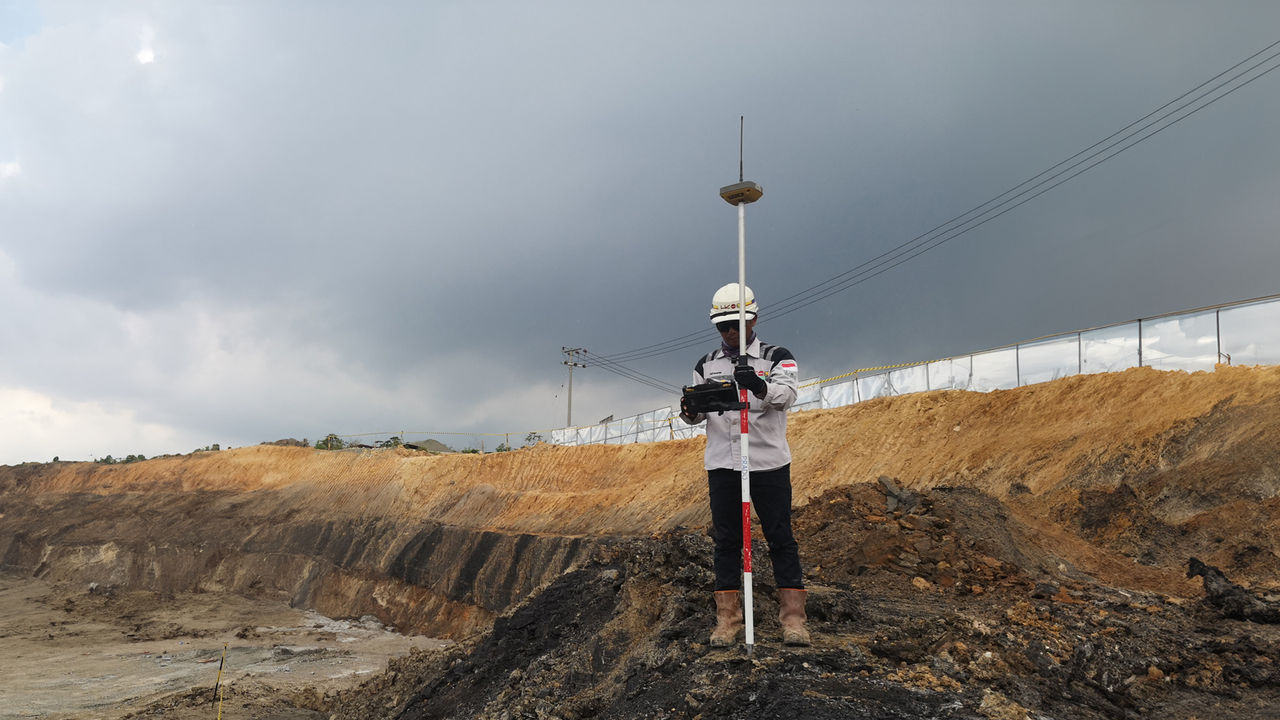
GNSS Receiver Case Study
HiPer VR
Accurate and fast surveying operations achieved with HiPer VR!
Please introduce your company.
Since officially established as Indonesia State Owned Enterprise in 1960, general contractors Hutama Karya have been engaged in various historical construction works in Indonesia. In 2014, Hutama Karya was assigned to work on an important infrastructure project — Trans Sumatera Toll Road — which connects from the southern part of Sumatera Island to the north. Since 2022, they have been entrusted again to work on a toll road project connecting the new Indonesian capital to the nearby city of Balikpapan.
Why did you choose HiPer VR?
We prefer HiPer VR rather than other brands because of its quality, durability and more affordable price. On our jobsites, we need GNSS mainly for Cross Section measurements and Cut and Fill. These works need below 2cm accurate vertical data and HiPer VR can fulfill this requirement. In addition, HiPer VR can easily achieve strong satellite signals and a strong connection between the base and rover, even in the middle of extreme topography conditions. This is a huge advantage for us because the survey can be faster and does not need many base station setups. Another thing that made us excited to use HiPer VR was the user-friendly software interface.
How do you use HiPer VR?
Usually, we have to prepare all the data such as design data for stakeout and some fixed data coordinates. The data is stored in the “.dwg” file and I import it to the MAGNET Field software in the FC-6000 controller. Just set up the first HiPer VR for measurement based on the control point and then connect it to another HiPer VR which has been set up as Rover. I usually use a radio connection to connect both receivers. Once both receivers are connected, I start the measurement by operating the MAGNET Field software. With the help of MAGNET Field software, HiPer VR is even more powerful and its user interface is also very easy to use.

How much did the productivity increase?
My first impression of using HiPer VR is its accuracy and data consistency. The high-accuracy sped up our vertical data measurements. Our work speed is now twice or maybe three times faster than with the conventional method (Total Station) or even other GNSS brands, which are expanding in the market and don’t have data consistency as good as HiPer VR has. This also reduces our effort spent on unnecessary rework.
How about the cost-effectiveness
Topcon HiPer VR is the most affordable high-end product that we ever purchased. Compared to competing brands in the same price range, HiPer VR is already a highquality product, quipped with various impressive features.
Company: PT. HUTAMA KARYA
Address: Jl. Letjen M.T Haryono Kav 8, Cawang. Jakarta Timur 13340
URL: https://www.hutamakarya.com/
TOPCON Product:
HiPer VR
MAGNET Field
FC-6000
Project: BRIDGE AND TOLL ROAD
Project Location: INDONESIA NEW CAPITAL TOLL ROAD
Related Item
News
Events
- Start Date
- 2024/12/20
- End Date
- 2024/12/20
- Event Details
-
Dates: December 20, 2024, (Friday)
Time: 10:00 a.m. - 12:00 p.m.
Venue: Sinnsathorn Tower Building, 11th Floor (Conference room)
Map: https://maps.app.goo.gl/Lu6YypSv9nmQznJv8
Registration [ Free] : https://www.surveymonkey.com/r/TOPCON_ESN
Organizer: Topcon Positioning Asia (Thailand) Co., Ltd.
- URL
- /content/topcon-pa/th/en/events/2024/08112024.html
- External URL
- Target
- _self
- Start Date
- 2024/10/16
- End Date
- 2024/10/18
- Event Details
-
Dates: 16-18 October 2024
Time: 09:00 am. - 5:00 pm.
Venue: BITEC Bagna, Hall EH101
Organizer: DIDACTA
- URL
- https://didacta-asia.com/
- External URL
- Target
- _blank