


- Start Date
- 2026/07/22
- End Date
- 2026/07/24
- Event Name
-
International Engineering Expo 2026
- Event Details
-
Period: 22-24 July 2026
Venue: Hall 55-56 | Queen Sirikit National Convention Center (QSNCC)
Booth No. D07: TOPCON POSITIONING THAI
Time: 10:00 am - 6:00 pm
- URL
- External URL
- Target
- _blank
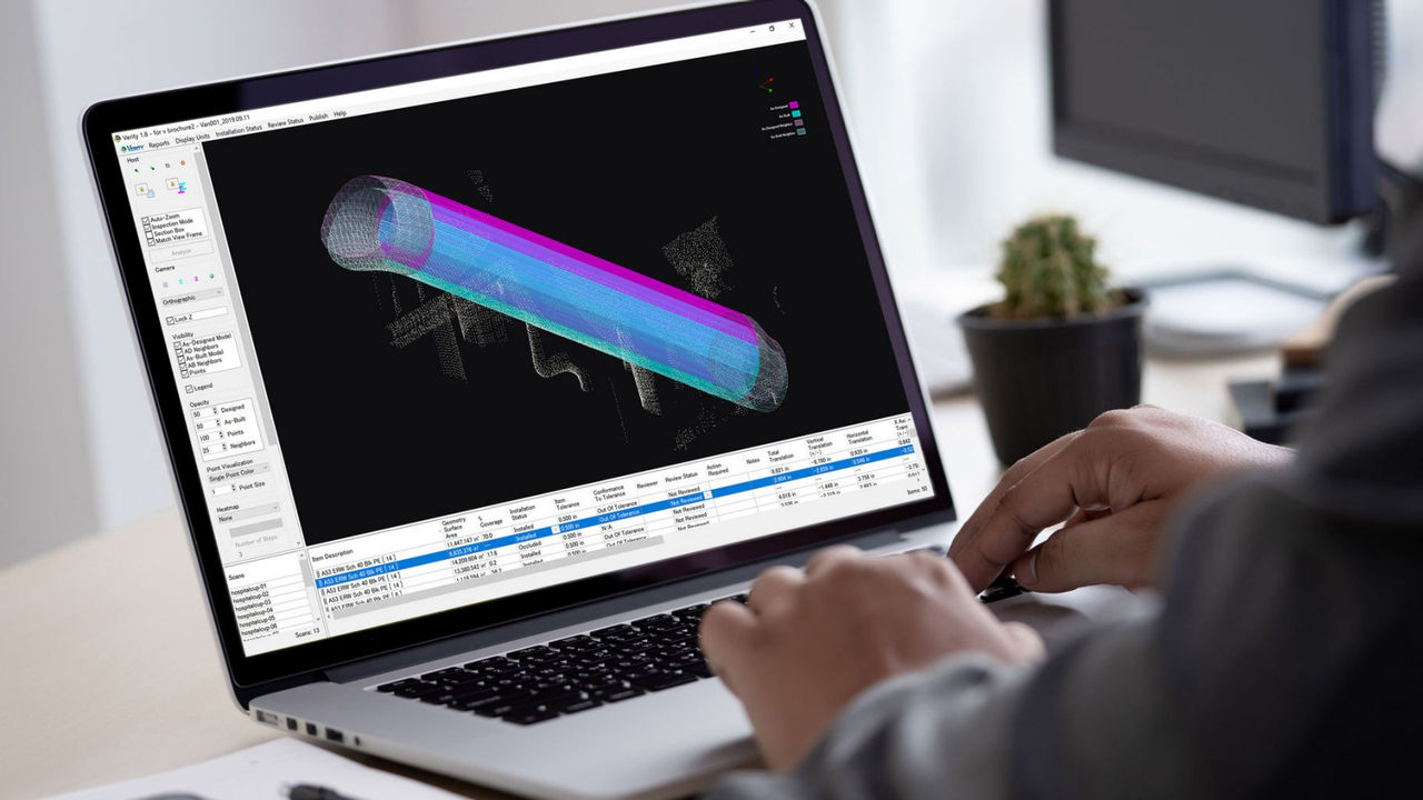
Verity
Construction Verification Software
Automatically Compare Point Clouds vs BIM Model and Visualize Installation Accuracy
- Instantly understand construction accuracy in 3D
- Efficiently compare laser scans of as-built conditions against any 3D Navisworks model
- Minimize risk of budget and schedule changes
- Non-contact inspection using point cloud data from laser scanner
- Export inspection results to project management platforms such as BIM Track, Procore and BIM 360
- Remotely conduct QA/QC via internet
- Add-on software to Autodesk® Navisworks®
Automatically Verify As-Built Point Cloud Against BIM Design Model

Sample Data Sets
Hospital Central Utility Plant

Brochure
Related Item
Related Case Study
Related Information
News
Events
- Start Date
- 2024/12/20
- End Date
- 2024/12/20
- Event Details
-
Dates: December 20, 2024, (Friday)
Time: 10:00 a.m. - 12:00 p.m.
Venue: Sinnsathorn Tower Building, 11th Floor (Conference room)
Map: https://maps.app.goo.gl/Lu6YypSv9nmQznJv8
Registration [ Free] : https://www.surveymonkey.com/r/TOPCON_ESN
Organizer: Topcon Positioning Asia (Thailand) Co., Ltd.
- URL
- /content/topcon-pa/th/en/events/2024/08112024.html
- External URL
- Target
- _self
- Start Date
- 2024/10/16
- End Date
- 2024/10/18
- Event Details
-
Dates: 16-18 October 2024
Time: 09:00 am. - 5:00 pm.
Venue: BITEC Bagna, Hall EH101
Organizer: DIDACTA
- URL
- https://didacta-asia.com/
- External URL
- Target
- _blank