


- Start Date
- 2026/03/31
- End Date
- 2026/04/01
- Event Name
-
Geo Connect Asia 2026
- Event Details
-
Geo Connect Asia 2026
Date: March 31 - April 1 (Tuesday - Wednesday)
Venue: Sands Expo & Convention Centre, Singapore
Time: 9:00am - 6:00pm
Organizer: Montgomery Group Asia
- URL
- https://www.geoconnectasia.com/
- External URL
- Target
- _blank
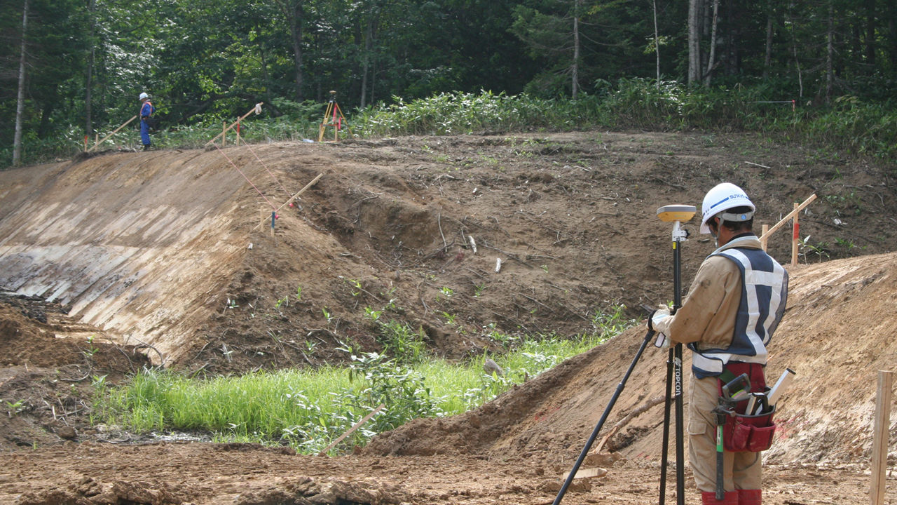
Site Receiver Case Study
HiPer SR
RTK-GNSS Streamlines Mountain Road Construction!
HiPer SR/Kantoku-san.V Combo Solves Sight Line Problems, Enables One Man Finishing Stake Installation
Sankyo Kensetsu Co., Ltd. is a construction company based in Shibetsu, Hokkaido, and was the first in northern Hokkaido to introduce the HiPer SR, a site receiver for construction that comprises dual-frequency GNSS receivers. The company paired the HiPer SR with Kantoku-san.V, a civil engineering application for data collectors, to install finishing stakes in the construction of reservoir access roads at the Sanru Dam on the Teshio-gawa River.
Differentiation through RTK-GNSS
Kenji Ono was the foreman of the Sanru Dam construction site, and he shared the story behind the introduction of RTK-GNSS. “Our initial plan was to use only a total station for the measurement so that we could use the same equipment to manage completed work,” Ono recalled. “However, the site was in the mountains. There were massive differences in elevation, and it was difficult to clear sight lines in many locations. Thus, we made the bold decision to use GNSS. Another major reason for our decision was that nobody else had ever used GNSS for road construction in this region; we could try to differentiate ourselves by being the first.”
Convenient Software Boosts Efficiency, Lowers Costs
Three engineers shared their views on the benefits of using an RTK-GNSS system. “When we use total stations in the mountains, we must frequently reposition equipment to ensure clear sight lines,” Sankyo Kensetsu Construction Department Supervisor and Surveying Manager Naoya Ichihashi said. “With the HiPer SR, we don’t have to worry about sight lines. We set up the fixed station, and use the Bluetooth-enabled mobile station to take measurements within a 300-meter radius.
And the fact that only one surveyor is required to take measurements improves the efficiency of our work immensely.” Construction Department Supervisor Norihisa Doi commented on the convenience of the software. “In the past, we had to do our surveying with coordinate calculation sheets in hand,” Doi said. “Kantoku-san.V does the calculations on-site as we install finishing stakes, so we no longer need to carry the sheets with us.” Construction Department employee Junya Izutani has also noticed an impact. “We used to have to spend one or two hours every day calculating measurements after finishing on-site,” Izutani said. “Now, we don’t spend any time at all on calculations. We’re also able to do the surveying work more quickly, so the total time required has decreased substantially.”
Application in Sectional Surveying and River Training Expected to Improve Evaluation Scores
“We used this combination of technologies on finishing stakes, but in the future I’d like to use it to take sectional measurements and calculate soil volumes,” Ichihashi said. “We also plan to use it for river earthwork [channel excavation and embankments].”
Ono also offered his views on the potential of this technology. “I plan to use the results of our experiment of using GNSS for surveying as a tool for selling our originality and ingenuity to clients,” Ono said. “I’ll be glad if it boosts our company’s image.” The company’s willingness to try new things may accomplish just that.
News
Events
- Start Date
- 2025/11/06
- End Date
- 2025/11/09
- Event Name
-
PhilConstruct Manila 2025
- Event Details
-
Date: November 6-9, 2025 (Thursday - Sunday)
Venue: World Trade Center Metro Manila & SMX Convention Center Manila, Philippines
Time: 9:00am - 6:00pm
Organizer: Philippine Constructors Association Inc. (PCA)
- URL
- https://philconstructevents.com/manila/
- External URL
- Target
- _blank
- Start Date
- 2025/10/28
- End Date
- 2025/10/31
- Event Name
-
BuildXpo 2025
- Event Details
-
Malaysia International Building and Construction Industry Showcase
Date: October 28–31, 2025 (Tuesday – Friday)
Venue: Hall 2 & 3, MITEC (Malaysia International Trade and Exhibition Centre), Kuala Lumpur, Malaysia
Organizer: Ministry Of Works, Malaysia (KKR), Malaysia & Construction Industry Development Board (CIDB)
- URL
- https://buildxpo.com.my/index.php
- External URL
- Target
- _blank